Tree Permitting

Did you know that any Washington DC resident or contractor who wishes to plant, prune, or remove a tree within the public right of way must first obtain permission from the District Department of Transportation (DDOT) and the Urban Forestry Division? However, knowing when, where, and how to get the right permit for tree work in DC can be a complicated process. Fortunately, DDOT has a new resource available to make it easy! Check out the Tree Permitting Hub site to answer all tree permitting questions.


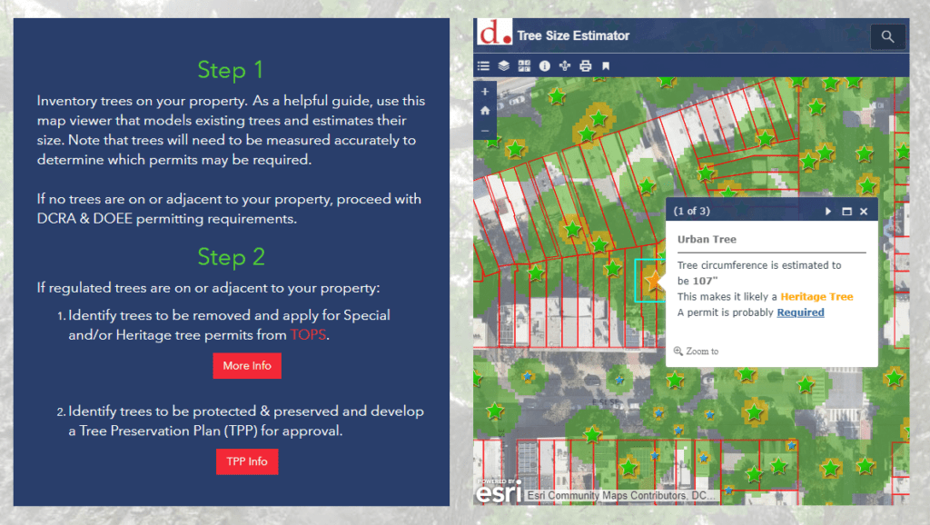
SymGEO built the Tree Permitting site using ArcGIS Hub technology, which leverages ArcGIS Online mapping and graphic examples to help explain what type of permit is needed based on tree location, property boundaries, and tree size. The site also explains the benefits of the Income Contingent Hazardous Tree Mitigation Program that provides assistance with the removal of a hazardous tree on an owner’s private property.

As an example of “good to know” information, Washington D.C. is unique in that it has dedicated park space along most streets. This “parking” area is generally used for landscaping, retaining walls, trees, and other greenery. Just like on private land, all landscape elements (including trees) in this parking area are the responsibility of the homeowner to maintain. On the other hand, all trees located in the public “sidewalk” area are the responsibility of the city to maintain. However, these trees may be negatively impacted by development or construction projects and need to be considered before projects begin.

Talk to our industry experts today if your agency or organization is interested in community engagement with the power of Esri’s ArcGIS Hub or mapping with ArcGIS Online – SymGEO is here to help!

Tree Preservation

Did you know that trees are so important to Washington DC that they are protected by the Urban Forest Preservation Act and the Tree Canopy Protection Act? This means that before performing any excavation or construction activity on private property, it is important to consider any potential impacts to the trees on site. To facilitate this process, SymGEO is proud to help DDOT launch a new resource, the Tree Preservation Hub site, for property owners and construction companies to identify which trees need to be protected and how to best take care of them during home renovations or new construction projects.

tree preservation hub site

Built using ArcGIS Hub technology, this site leverages ArcGIS Online mapping and graphic examples to help explain what type of permit or protection plan is needed based on estimated tree size. Tree sizes were estimated using LiDAR processing, which in turn is used to estimate the critical root zone and structural root zones that need to be protected during construction. Modeling several hundred thousand trees at the same time has its challenges; however, ArcGIS Pro, ArcGIS Enterprise, Arcade expressions, and hosted image services were used to efficiently capture and share the modeling results.

Talk to our industry experts today if your agency or organization is interested in community engagement with the power of Esri’s ArcGIS Hub or data processing with ArcGIS Pro – SymGEO is here to help!

Arbor Day

“Every day is Arbor Day in the City of Trees!” – these wise words from Dr. Kasey Yturralde, the Forest Health and Community Outreach Specialist at DDOT’s Urban Forest Division (UFD), are a great indicator of the passion and excitement possessed by the entire UFD team keeping our city green and beautiful.

With that in mind, SymGEO is pleased to announce a brand new interactive Arbor Day at Home resource for communities and individuals who share the same passion for our neighborhood trees. This dynamic website, built with ArcGIS Hub technology, showcases a number of best-practices when planting or caring for trees, as well as fun activities for the whole family in identifying local tree varieties.

Talk to our industry experts today if your agency or organization is interested in community engagement with the power of Esri’s ArcGIS Hub – SymGEO is here to help!

Urban Forest Health

SymGEO is pleased to announce the launch of a Forest Health website for DDOT’s Urban Forest Division (UFD), designed to educate the community on how DDOT (and DC residents!) help keep the urban canopy vibrant, healthy, and productive. In a natural ecosystem, there are many checks and balances to keep a forest healthy. Urban environments present many challenges to trees, which include the urban heat island effect, degraded soil, limited growing space, and the introduction of exotic pests. This can lead to pest infestations and canopy damage if not caught quickly and mitigated efficiently. Fortunately, at the DDOT Urban Forestry Division, dedicated specialists prevent and respond to urban forest health issues on a daily basis.

“We are excited to share our forest health programs with the public in this new format. The new forest health website is dynamic and easy to use, it allows users to learn about pests and pathogens to look out for, while also giving them the opportunity to report their observations.”

– DDOT Urban Forestry Division

The new Forest Health site discusses a range of preventative measures the UFD takes against pests, including the Early Detection Rapid Response (EDRR) and the Cryptic Wood-Borer Insect (CWBI) programs, as well as how DC residents can identify and report invasive species.

The site leverages Esri’s ArcGIS Hub framework for design and mobile responsiveness and Esri’s Survey123 for ArcGIS for pest reporting. Information is gathered through the website, including pest species, life stage, or signs/symptoms, and is passed to the survey to help the reporting process along.

A Pest Vulnerability Matrix (PVM) is also presented which enables urban foresters to evaluate the overall vulnerability of the urban forest and evaluate the potential impacts of emerging pests and diseases.

Talk to our industry experts today if your agency or organization is interested in community engagement with the power of Esri’s ArcGIS Hub – SymGEO is here to help!